Thu Oct 13 & Fri Oct 14 Outlook
Strong cold front moves through WAS and NYC during Thu evening; we resume speculating about record-setting traveler volumes.
Welcome to any new readers! And as a reminder to long-ish time readers, we’re testing a new format for these outlooks. To both old and new—we’re grateful you’re here.
If you have questions about the content of this outlook, the answers might be in this post (we keep adding to it). Otherwise, let us know if something doesn’t make sense (we welcome feedback of all kinds!).
Thursday, October 13
We forecast TSA will screen 2.432 million travelers (± 0.5σ, or a prediction interval of about 38%, is 2.37-2.50 million travelers).
Five days into ORD’s October schedule change and they’ve managed without a late afternoon/early evening ground stop thus far. We’ll need to wait until mid- to late-November for a fuller picture (inclusive of metering, MIT, MINIT delays), but initial indications are disruption resulting from the new 6 p.m. arrival demand peak is largely imperceptible.
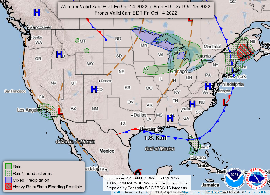
Despite the sort order, the focus of tomorrow’s story figures to be NYC, where scattered showers will develop by early afternoon ahead of a strong cold front. A more organized band of moderate to heavy showers is expected along the frontal boundary during evening. A strong onshore flow and evening frontal passage somewhat inhibit—but don’t rule out—thunder. While JFK might be slightly better equipped to handle the gusty south-southeasterly winds, their chances nevertheless feel a bit underdone.
To the south, the ingredients for convection—while still a bit uncoordinated—are more favorable around DCA (and Dulles, for that matter). Here the question seems to be whether severe storms1 develop (not whether storms develop at all).
Friday, October 14
We forecast TSA will screen 2.494 million travelers (± 0.5σ, or a prediction interval of about 38%, is 2.43-2.56 million travelers). Traveler volumes continue their quick recovery from an Ian-induced slump, with the 7-day moving average having returned to early August-levels. And for the first time in a few months, we again get to bet on setting a new high-water mark. No longer belonging to the Sunday after Thanksgiving 2021 (2.45 million screened), July 1 currently owns the recovery record (2.49 million screened). We give Friday about a 50/50 chance to exceed July 1’s checkpoint volume (to Thursday we extend 3 in 10 odds).
More tranquil weather conditions are on-tap for potential record-setting traveler volumes on Friday. Even the rain hatching in the vicinity of ORD owes to chances at the end of the chart’s valid period (i.e. Saturday morning).
You can check out2 hourly estimates in this workbook.
Primary threat looks to be a damaging wind gust, though can’t totally discount a tornado or two.
While it links to a Google Sheet, it’s an Excel file and relies on the XLOOKUP function, which does not exist in Sheets. You can download the file and open in Excel, which should resolve the #NAME? error; if any readers don’t have Excel, let us know and we can work on a solution.


