[Spring Break] Sunday Mar. 20 travel
Gusty northwest winds at EWR, rain showers at SEA may produce afternoon and evening delays; risk for disruption lower at SLC and MIA.
Welcome to any new readers—we're grateful that you're here! We're building deep learning algorithms to democratize flight delay predictions; until we launch, we're eager to synthesize things manually in our outlooks. These feature several recurring themes that we recognize may be unfamiliar or intimidating, so we’ve written explainers that tackle airport arrival rates, queuing delays in the airspace and different tools to distribute those delays. If there’s a topic or mechanism you’d like to see unpacked, please let us know (same goes for special travel occasions).
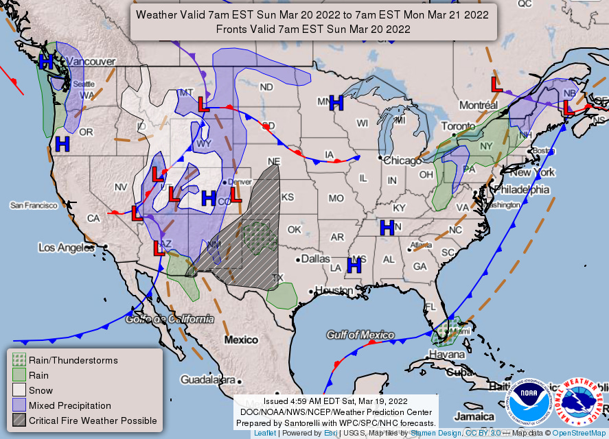
Yesterday, the TSA screened 2.31 million travelers, which was good for third most since COVID’s onset. (The current high-water mark is 2.45 million and belongs to the Sunday after Thanksgiving 2021.) If 2021 patterns hold—and they broadly have so far this March—we can expect Sunday volumes to be 4.4% higher than Friday this weekend, which yields 2.41 million (good for second highest). Those rooting for a new checkpoint record need not abandon all hope, however, as our Holt-Winters forecast gives tomorrow a 23% chance of exceeding 2.45 million. The weather backdrop for Sunday air travel is already taking shape, as a storm system that comes ashore along the West Coast this morning will swing into the Intermountain West tonight. Let’s get into the dynamics for individual airports… and for anybody following along in the TAFs, a reminder1 that the GMT offset is now one hour less.
Seattle (SEA)
We’ll get underway in Seattle then work our way east. After a brief break between systems Sunday morning, a warm front will spread rain into the area for the afternoon and evening. We think 42 is a good arrival rate floor (less than 1 in 10 chance for lower rates) here, albeit not that unlikely (at least 1 in 5 chance for equal rates). Twice scheduled demand2 is above our floor: in the 10 a.m. (47 arrivals) and 8 p.m. (46) hours. With showers withheld from the TAF through mid-morning, let’s focus on the evening overage (which is exacerbated by some scheduled backloading). We expect the FAA will take a wait-and-see approach, which would leave a first tier ground stop to reach for if a 42 arrival rate materializes in the 8 p.m. hour. We’ve modeled average delays of 27 minutes3 for captured flights in this case.
Salt Lake City (SLC)
Precipitation associated with the storm system mentioned at the top of this post will becoming more organized and banded along/ahead of an associated cold front. This band will enter north- and central-western Utah during the pre-dawn hours of Sunday then move east-southeastward through the remainder of the day. Expected snowfall is just underneath 2” (with high end amounts around 3”), however the forecast discussion notes that warm surface temperatures and the mid-March sun angle should inhibit accumulation. Gusty post-frontal winds will develop by late morning: Blowing snow may hamper snow removal, however the north-northwest direction is at least favorable.
Scheduled demand peaks at 32 and we’d set our arrival rate floor at 60 (less than 1 in 20 chance for lower rates); even an unreasonably pessimistic estimate would call for an arrival rate of 30. We’ll call out unscheduled demand here—it adds 40.5% on top of scheduled demand, most among the airport we’re considering—but that only moves the risk from very low to still-pretty-low. Separate from any air traffic delays resulting from a capacity/demand imbalance, deicing delays for departures should be expected anytime snow is falling.
Miami (MIA)
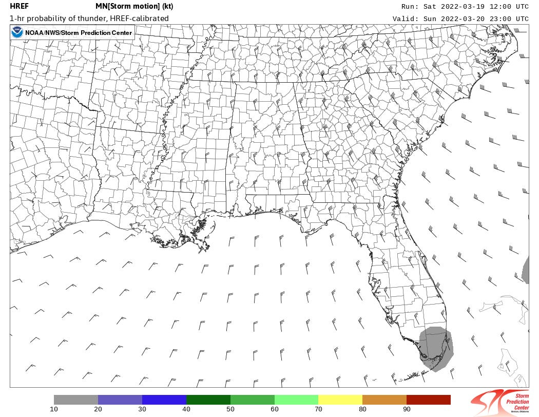
Ahead of an approaching front, winds over South Florida will gradually veer to southwesterly Saturday night, drawing in Caribbean moisture. Atmospheric conditions are not overly-favorable for the formation of thunderstorms, however daytime heating—even during early spring—is enough to keep a slight chance (1 in 4 or so) for thunder in the forecast. It is worth noting, with the aforementioned front being a slow-moving one, any storms that do form are liable to train over the same area. While we don’t think they’ll advertise anything less than a 60 arrival rate, it’s possible (i.e. 1 in 4) they’d actually land as few as 15 aircraft per hour if thunderstorms develop [and train] over the airfield. Resulting delays in such a scenario are difficult to model due to the diversions that would likely follow. A slightly less severe, albeit more probable, form of disruption would be a ramp closure4 due to vicinity lightning strikes that temporarily suspends aircraft turnarounds. Fortunately, high-resolution ensemble guidance keeps probabilities for thunder at less than 20%.
Newark (EWR)
A weak cold front will pass through the Tri-State region on Sunday, with any showers widely scattered and likely confined to areas northwest of the metro. More problematic will be west-northwest winds gusting to 25 knots, which could force an unfavorable runway configuration at EWR. While we think arrivals and departures sharing Runway 29 is improbable (on the order of 1 in 50 chance), we wouldn’t bet against the gusty northwest winds eating away at capacity in some form. If arrivals are pushed to Runway 29 while departures hang onto 22R, which we would give at least a 1 in 5 chance of occurring, then a 38 arrival is more likely than not. If both arrivals and departures are able to utilize the 22’s (with arrivals to 22L), there’s still a 3 in 10 chance for arrival rates less than 40. That’s a lot of conditional probabilities: All-in, we think 36 is a good arrival rate floor (1 in 8 chance for equal or lower rates) while there’s nearly a 1 in 4 chance for a 38 arrival rate.
Our thoughts are with the people of Ukraine, especially the Kyiv-based designer we partnered with this past fall.
Miles4Migrants, which United and Delta previously partnered with, indicates NGO’s haven’t begun to submit requests for displaced Ukrainians. In the interim, they recommend donating to their partners IRC, HIAS, and UNHCR. Not waiting for Miles4Migrants, United and American have kicked their miles donation programs into gear, with Airlink a beneficiary (among others). Additionally, Lufthansa’s Innovation Hub had a nice round-up of travel-centric donation options in their most recent newsletter.
If your experience reading this post is anything like ours writing it, you’ll check Jon Ostrower’s Open Source Intelligence list on Twitter between every sentence. Given the prevailing tone on social media, we’ll be doing less self-promotion for the time being—with that said, we’d be particularly appreciative of anybody who shares this bit of writing.
Scheduled arrival demand at EWR peaks at 45 (in the 7 p.m. hour). If a 38-rate materializes, we could envision a ground delay program with a 1,200 mile scope. This was the case last Sunday (on account of wind) and average delays were 35 minutes (with a maximum delay of 88 minutes).
Recommendations
Though no weather waivers have been issued that cover Sunday travel, we will take the opportunity to remind readers that airlines have meaningfully improved general rebooking flexibility by eliminating change fees for most tickets (though a fare difference may still apply). Predicability is best for itineraries that transit SEA and EWR and we’d at least look at other options if:
the trip starts in the Pacific Northwest, Intermountain West or Northern California and includes a layover at SEA around 9 p.m. that cannot absorb a delay of at least 30 minutes;
or the trip starts in eastern half of the US and includes an afternoon or evening layover in EWR that cannot absorb a delay of at least 35 minutes.
Predictability is poor for itineraries that transit MIA and we’re inclined to recommend rebooking for only the most risk-averse travelers (and only for connections around 7 p.m.).
Fine. That may have been more of a self-reminder.
Cargo airlines as well as private jets are not included in scheduled demand and only become apparent when they file a flight plan (generally day-of). This unforeseen demand introduces the risk that delay probabilities/intensities are under-forecast. Unscheduled demand added 15.3% to scheduled demand for Core 30 airports month-to-date (through Mar. 17). For the airports we’ll consider today, unscheduled demand adds 6.5%, 40.5%, 28% and 8.6% for SEA, SLC, MIA and EWR, respectively.
While our modeling is aimed at tackling arrival delays, there's a strong correlation to departure delays (albeit with some lag and/or possible alleviation). Consider a scheduled "turn" at an airport: the inbound flight is scheduled to arrive at 2:19 p.m. and departs at 3:30 p.m. (71 minutes of turnaround time). Let's say the inbound is delayed by 40 minutes and instead arrives at 2:59 p.m. We'll further assume that the airline doesn't need the full 71 scheduled minutes to turn the aircraft and can accomplish the turn in 45 minutes if they hustle - the departure will push back from the gate at 3:44 p.m. (delayed by 14 minutes). In this example, a 40 minute arrival delay in the 2 p.m. hour is partially passed through to a departure in the 3 p.m. hour. Had the turnaround been scheduled at 45 minutes instead (i.e. no turnaround buffer), the lag between arrival and departure delay would still exist, however the delay would be fully passed through.
Additionally, our efforts are aimed at diagnosing air traffic delays (i.e. those that result from an imbalance between capacity and demand). Though not the focus of our efforts (yet), delays owing to aircraft servicing, airline staffing, network effects, etc. are always lurking.
When lightning occurs in the vicinity of the airport, baggage handlers and fuelers (among other workgroups) are pulled off the ramp, thus halting aircraft turnarounds.


Nice work you're doing
I'm glad we crossed paths on yesterday's "road tour!" When I'm not on here writing about music, I can be found at the airport, where I work for one of the Big 3. I've been looking for aviation-related work on Substack without much luck. Really appreciate the data-driven look at the system as a whole as well.