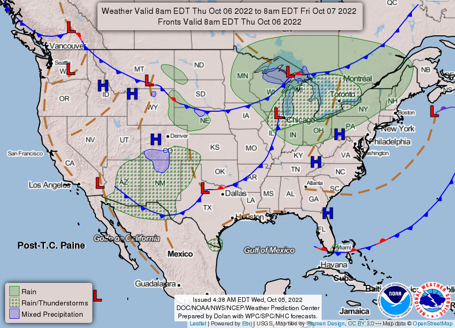
Thu Oct 6 & Fri Oct 7 Outlook
A strong cold front pushes south and east across Midwest then Northeast; schedule change at ORD brings new early evening peak.
Welcome to any new readers! And as a reminder to long-ish time readers, we’re testing a new format for these outlooks. To both old and new—we’re grateful you’re here.
If you have questions about the content of this outlook, the answers might be in this post (we keep adding to it). Otherwise, let us know if something doesn’t make sense (we welcome feedback of all kinds!).
Thursday, October 6
We forecast TSA will screen 2.166 million travelers (± 0.5σ, or a prediction interval of about 38%, is 2.10-2.23 million travelers).
As an aside, Ian almost succeeded in pushing the 7-day moving average of TSA throughput below 2 million—a (psychologically important?) threshold we’ve remained above since early March. After yesterday, the 7-day moving average sits at 2.01 million. For those invested in such things, we think there’s a better than 4 in 5 chance that more travelers are screened today than last Wednesday (in which case the 7-day moving average would bounce). And estimate there’s only a 6% probability that today’s checkpoint volumes are light enough to drag the 7-day moving average below 2 million.
A strong cold front will quickly sink through ORD during afternoon. Post-frontal showers are expected and a few rumbles of thunder are possible; northerly winds also increase behind the front. Perhaps more notable is an October schedule change1 that sees 117 scheduled arrivals in the 6 p.m. hour… notable because ORD’s optimal rate is 114. We’d manually adjust our overage probability up for ORD tomorrow (the chance of thunderstorm creates a small sample size, which—in this case, too aggressively—de-weights a near-certain hourly probability).
Friday, October 7
We forecast TSA will screen 2.220 million travelers (± 0.5σ, or a prediction interval of about 38%, is 2.16-2.28 million travelers).
The cold front moves through the NYC area on Friday, though moisture is lacking and better chances for showers looks to be to the northwest.
The mixed precipitation hatching continues to inch close to DEN, though the short-range ensemble forecast (SREF) keeps snow and ice probabilities at zero.
You can check out2 hourly estimates in this workbook.
Demand varies somewhat by day of week, with Saturdays “relaxing” to near 104. This is up from approximately 97 in September.
Charts from Monday, October 3 (pre-schedule change) and Thursday, October 6 (post- schedule change) below. Note different lower bound to vertical axis.
While it links to a Google Sheet, it’s an Excel file and relies on the XLOOKUP function, which does not exist in Sheets. You can download the file and open in Excel, which should resolve the #NAME? error; if any readers don’t have Excel, let us know and we can work on a solution.


Not looking forward to that cold front coming through the upper Midwest tomorrow; we've already deiced a few times over the last 10 days, and that's a few times too many...