Checking-in on early fall TSA throughput
Plus our Thursday, Sep. 22 & Friday, Sep. 23 Outlook
We’re now two weeks on from the bulk of Labor Day Weekend’s influence and a couple [at least mildly] interesting trends have emerged in TSA throughput data.
To level-set, we’d recently suggested that the TSA may have gotten lost in their own weekday mapping and, as a result, errantly claimed to have screened more travelers over the 2022 Labor Day holiday weekend than 2019. We still stand by this1 intimation (look at the Sundays!), but it turns out the TSA may have only been premature in their recovery declaration (perhaps not wrong). While we maintain the long weekend as a whole saw fewer travelers in 2022 than 2019, return travel on Monday and Tuesday looked to be busier than three years ago; perhaps it’s an indicator of changing travel behaviors (i.e. week- or month-long trips that concluded on Labor Day, rather than weekend trips).
Importantly, this return travel bump softened the blow of a characteristic post-Labor Day dive. By our accounting, 2022’s 7-day moving averaged crossed above 2019’s for the first time during the weekend after Labor Day. And while 2019 has re-established its lead over 2022, the cushion appears to have narrowed. For much of the summer, 2019’s 7-day moving average sat about 300,000 screenings above this year; after yesterday, September 20, the gap is less than 100,000 (and showing signs of steadiness). On percentage basis, screenings for the 7 days-ending yesterday were 95.8% of the equivalent period in 2019 (after July 1, 2022, it was 88.9% of 2019 equivalent).
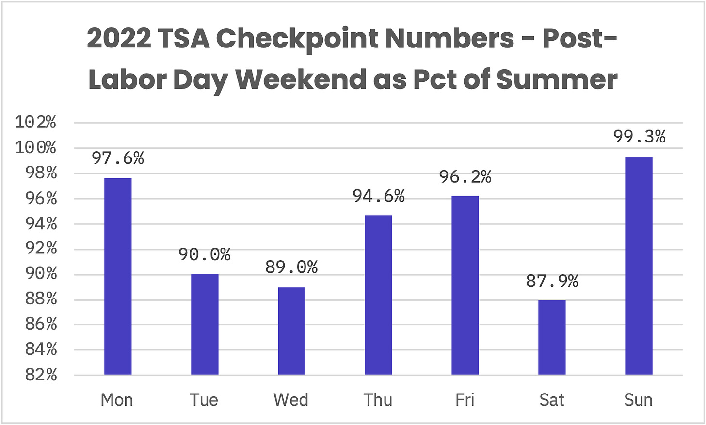
This resiliency in traveller volumes during early fall has also yielded some curious comps vis-à-vis late summer volumes. Following yesterday, the 7-day moving average equaled 2.15 million screened: higher than the 7 days-ending August 26, 2022. In 2019, the 7-day moving average wouldn’t revisit August 26th levels until the equivalent of October 18. Interestingly, some weekdays are proving to be more buoyant than others. Checkpoint volumes for the last two Sundays have held up especially well, having ticked down just 0.7 percentage points versus summer Sundays—doubly impressive given that capacity was down 2.2%. (RIP NRSA’s.)

To this end, we’re going to pare back our outlooks from thrice to twice weekly—publishing on Saturday to cover travel on Sunday and Monday and again on Wednesday (to cover Thursday/Friday travel). As long as volumes remain relatively relaxed for some weekdays, we’ll take the opportunity to allay some of our concerns about spamming your inbox. Of course, if you have a trip on a Tuesday, Wednesday or Saturday that you’re concerned about, reach out—we’re happy to take a look at individual itineraries!
Thursday, September 22
We forecast TSA will screen 2.283 million travelers (± 0.5σ, or a prediction interval of about 38%, is 2.22-2.34 million travelers).
It appears there was an issue with this morning’s 07Z National Blend of Models run: visibility data is missing through 18:00 GMT tomorrow, September 22 (2 p.m. ET/11 a.m. PT). That unfortunately zero’s out much of our historical sampling, so probabilities in today’s post should be taken with an extra grain of salt.
With that qualification… a strong cold front is sent through the Mid-Atlantic and Northeast on Thursday morning. The best moisture exists around NYC, where there’s a potential for strong to possibly severe thunderstorms during the morning and early afternoon. Otherwise, there remains some disagreement about where the axis of heaviest rain sets up; regardless, the brunt of rainfall will be focused on morning hours in the wake of the frontal passage. The front appears to weaken and dry out as it stretches south—providing cause for optimism for ATL and CLT (less so for not-far-enough-south DCA).
Elsewhere, tropical moisture surges northward to the Central Rockies, though the heavy rain threat doesn’t look to escape from the high country to the urban corridor in which DEN resides.
Friday, September 22
We forecast TSA will screen 2.278 million travelers (± 0.5σ, or a prediction interval of about 38%, is 2.22-2.34 million travelers).
Welcome to any new readers! And as a reminder to long-ish time readers, we’re testing a new format for these outlooks. To both old and new—we’re grateful you’re here.
If you have questions about the content of this outlook, the answers might be in this post (we keep adding to it). Otherwise, let us know if something doesn’t make sense (we welcome feedback of all kinds!).
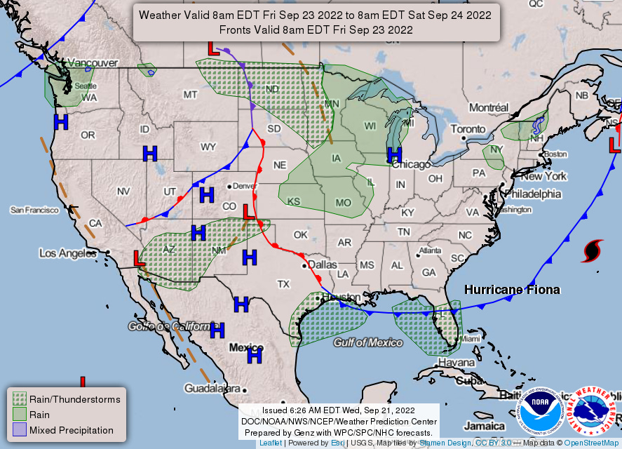
Brisk northwest winds may render Runway 22 unavailable at LGA: September’s 6 p.m. peak in scheduled arrival demand could prove a bit difficult to handle. A cluster of showers is forecast develop west of ORD and propagate east, though thunder chances are negligible. Elsewhere, we spy New England’s first mixed precipitation hatching of the season!
You can check out2 hourly estimates in this workbook.
If you don’t shift 2019 values from the TSA’s throughput data forward by one week, you end up with a clashing year-over-three relationship.
While it links to a Google Sheet, it’s an Excel file and relies on the XLOOKUP function, which does not exist in Sheets. You can download the file and open in Excel, which should resolve the #NAME? error; if any readers don’t have Excel, let us know and we can work on a solution.


I am 100% NOT ready for any "mixed precip," "wintry mixes," anything else winter-related.