


Thu Nov 3 & Fri Nov 4 Outlook
DEN looks to receive first measurable snowfall of season on Thursday; same system pushes cold front through DFW-area on Friday

Welcome to any new readers! And as a reminder to long-ish time readers, we’re testing a new format for these outlooks. To both old and new—we’re grateful you’re here.
If you have questions about the content of this outlook, the answers might be in this post (we keep adding to it). Otherwise, let us know if something doesn’t make sense (we welcome feedback of all kinds!).
Thursday, November 3
We forecast TSA will screen 2.210 million travelers (± 0.5σ, or a prediction interval of about 38%, is 2.15-2.27 million travelers).

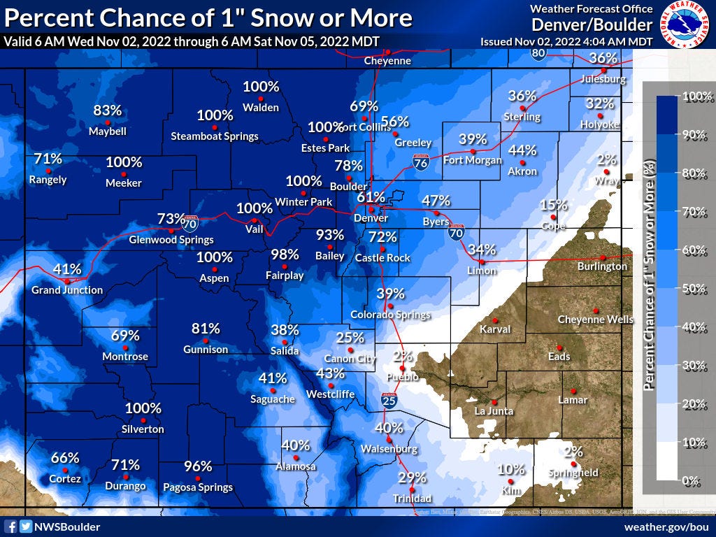
A slowing system should start to produce snow for the central Rockies tonight. As it moves off the mountains late Thursday, at least some snow should mix in with rain. The slowing trend has conveyed somewhat higher snowfall forecasts—albeit with considerable uncertainty—given that more of the precipitation will fall during the cooler evening hours. NWS Boulder puts chances of measurable snow (i.e. at least a tenth of an inch) for DEN at 87%; probabilities for at least one inch of snow are 61%1.
On a flight schedule-related note, ORD looks to be settling into a November schedule with peak scheduled arrival demand of around 106 flights. This is notable because they spent much of October around 117, which is above their optimal rate of 114.

Friday, November 4
We forecast TSA will screen 2.253 million travelers (± 0.5σ, or a prediction interval of about 38%, is 2.19-2.31 million travelers).

The same system that produces heavy mountain snow on Thursday will send a cold front across the Plains on Friday. For the DFW-area, convection will ignite along this front during mid- to late-afternoon. Apparently disorganized clusters of storms may initially develop, though these should quickly merge to form a more-organized line of storms; conditions are fairly supportive of severe weather.
Despite the thunderstorm hatching around ORD, NWS Chicago omits mention of thunder from their forecast.
You can check out2 hourly estimates in this workbook.
While it links to a Google Sheet, it’s an Excel file and relies on the XLOOKUP function, which does not exist in Sheets. You can download the file and open in Excel, which should resolve the #NAME? error; if any readers don’t have Excel, let us know and we can work on a solution.